brochure du produit ecomapper auv
détails techniques et fonctionnalités du ecomapper auv

Contenu du document
EcoMapper AUV
Générer des cartes haute résolution de la qualité de l'eau, des courants d'eau, de la bathymétrie et de l'imagerie sonar
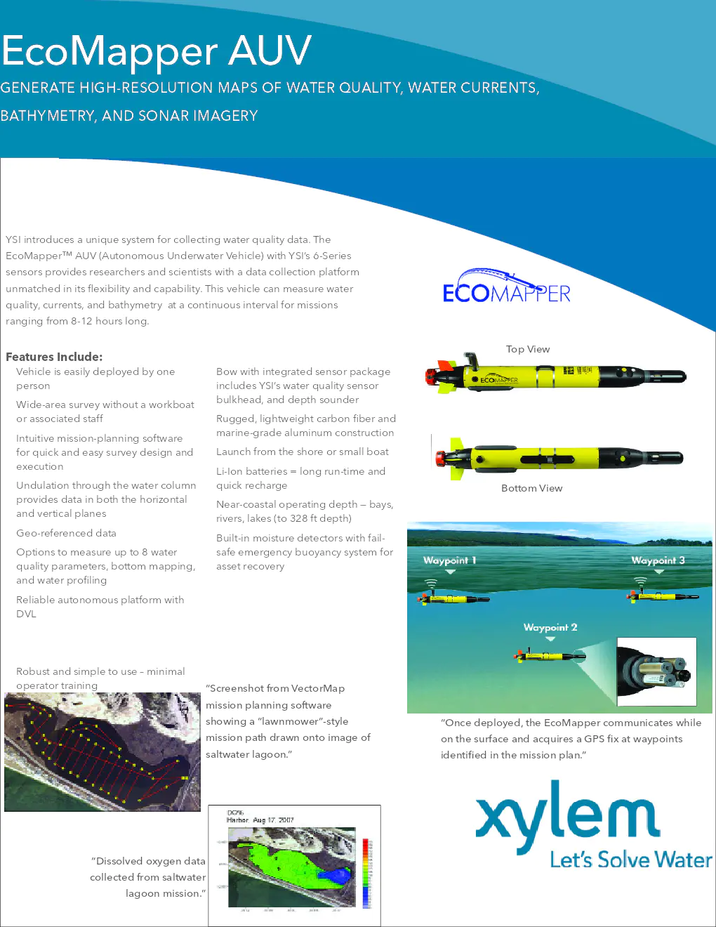
YSI présente un système unique pour collecter des données sur la qualité de l'eau. L'EcoMapper™ AUV (Autonomous Underwater Vehicle) avec les capteurs de la série 6 de YSI offre une plate-forme de collecte de données inégalée en termes de flexibilité et de capacité. Ce véhicule peut mesurer la qualité de l'eau, les courants et la bathymétrie à intervalle continu pour des missions allant de 8 à 12 heures.
Caractéristiques
- Déploiement facile par une seule personne
- Coque avec ensemble de capteurs intégrés comprenant le capteur de qualité de l'eau de YSI et un sondeur de profondeur
- Enquête à grande échelle sans bateau de travail ni personnel associé
- Construction robuste et légère en fibre de carbone et aluminium de qualité marine
- Logiciel de planification de mission intuitif pour une conception et une exécution rapide et facile de l'enquête
- Lancement depuis le rivage ou un petit bateau
- Utilisation de batteries Li-Ion pour une longue autonomie et une recharge rapide
- Fonctionnement près des côtes — baies, rivières, lacs (jusqu'à 328 pieds de profondeur)
- Capteurs d'humidité intégrés avec système de flottabilité d'urgence pour la récupération des actifs
- Plateforme autonome fiable avec DVL
- Utilisation robuste et simple – formation minimale de l'opérateur
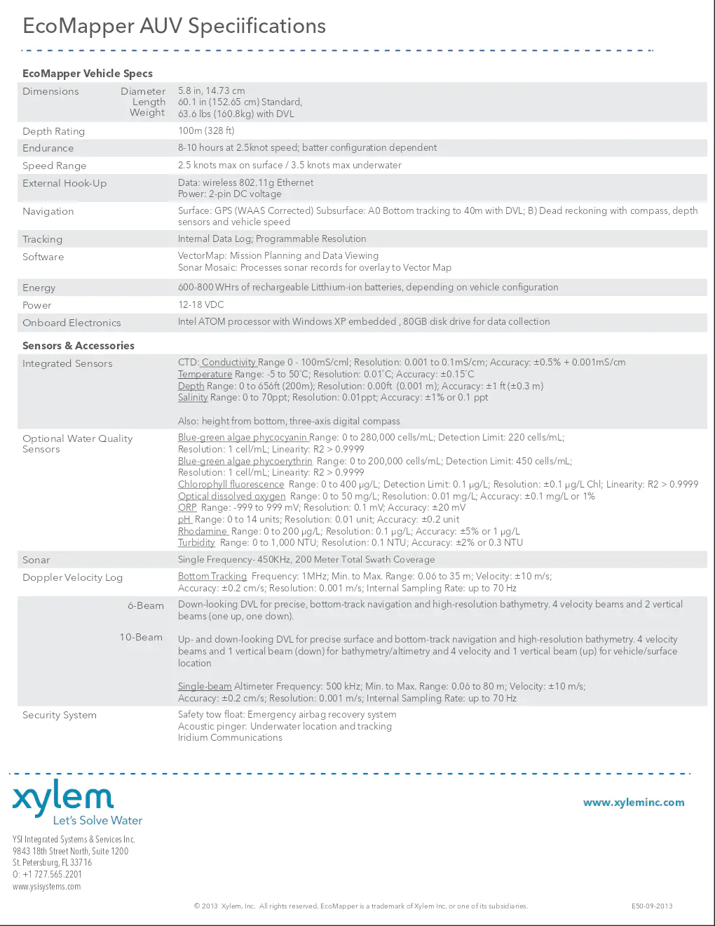
Spécifications de l'EcoMapper AUV
- Dimensions : Diamètre 5.8 in (14.73 cm), Longueur 60.1 in (152.65 cm) Standard, Poids 63.6 lbs (160.8 kg) avec DVL
- Profondeur : 100 m (328 ft)
- Autonomie : 8-10 heures à 2.5 nœuds, dépend de la configuration de la batterie
- Vitesse : 2.5 nœuds max en surface / 3.5 nœuds max sous l'eau
- Connexion externe : Données : Ethernet sans fil 802.11g, Alimentation : tension continue 2 broches
- Navigation : Surface : GPS (corrigé WAAS), Subsurface : suivi de fond jusqu'à 40m avec DVL, Estimation de position par boussole, capteurs de profondeur et vitesse du véhicule
- Suivi : Journal interne des données ; Résolution programmable
- Logiciel : VectorMap : planification de mission et visualisation des données, Sonar Mosaic : traitement des enregistrements sonar pour superposition sur la carte vectorielle
- Énergie : 600-800 WHrs de batteries lithium-ion rechargeables, selon la configuration du véhicule
- Électronique embarquée : Processeur Intel ATOM avec Windows XP intégré, disque de 80GB pour la collecte de données
- Capteurs intégrés : CTD, température, salinité, etc.
- Système de sécurité : Flotteur de remorquage de sécurité, système de récupération d'airbag d'urgence, communication Iridium
YSI Integrated Systems & Services Inc.
9843 18th Street North, Suite 1200
St. Petersburg, FL 33716
Tél : +1 727.565.2201
Site web : www.ysisystems.com
© 2013 Xylem, Inc. Tous droits réservés. EcoMapper est une marque de commerce de Xylem Inc. ou de l'une de ses filiales.


